About The Boonesborough Historical SocietyOriginally the Donalds Historical Society, growth and expanded membership were behind the name change to the Boonesborough Historical Society. The Society is a non-profit organization dedicated to the preservation and sharing of local history. The BHS serves the South Carolina towns of Donalds, Due West and Honea Path and covers parts of Abbeville and Anderson Counties.A Brief HistoryThe Donalds Historical Society was organized in 1991 by Jane Wilson, Nan Barmore, and Jane Stone. Meetings commenced in Riley Stone's former store and officers were elected. Lewis Johnson served as President of the newly formed Society. Later presidents were Riley Stone and Robert Drake. Ruth Stone served as secretary/treasurer for many years while Jane Wilson continuously published the newsletter.MeetingsThe BHS disbanded in the late 2000s.
Current Projects
Restoration of the Templeton-Drake Log House -
Donations for the restoration of the Templeton-Drake house should be made out to the BHS - Log Cabin Fund. Past ProjectsIn December 1992 the Donalds Historical Society sponsored the first Donalds Homecoming to commemorate the 150th anniversary of the town. Since then, the Society has been involved in several projects:
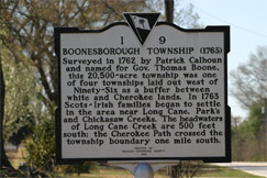
Publications1993 - Boonesborough Township: Plats, Trails and Towns, 1763 through 1775 by C. Newell Bowie1993 - The Settlement of Boonesborough Township, South Carolina by Wofford E. Baldwin, M.D. Due West, SC 1996 - Greenville Presbyterian Church Cemetary and Genealogical Data, 1769 through June 1996 2001 - Boonesborough Township 1762 - 1775: Townships, Colonial Plats, Immigrants & Cherokee Trail by C. Newell Bowie Books Our Members Have Written1993 - Remembrance: A Family Chronicle by Elizabeth Reid Austin1997 - Mount Pleasant, the Victorian Village by Mary-Julia Royall 1993 - Jimmy: An Austin Chronicle by Elizabeth Reid Austin 2001 - Thru All These Years: A Memoir of a Southern Family by Mary Elizabeth Graham Lindley 2001 - Mount Pleasant, The Friendly Town by Mary-Julia Royall 2002 - A COLLECTION OF STONES and most of them...Gems by Ilona Hinrichs Stone About Boonesborough TownshipFor immigrants who were expected as a result of bounty encouragement, three square-shaped townships were in laid out in 1762 west of Ninety-Six: Boonesborough; Hillsborough, 28,000 acres centering near where Long Canes enters Little River and containing the town of New Bordeaux; and Belfast (later often called Londonborough), comprising 22,000 acres and lying on both sides of Hardlabour Creek above its junction with Cuffeetown Creek.The survey of Boonesborough Township was certified 20 December 1762 with the township covering 20,500 acres. The Boonesborough name was in honor of the new Royal Governor of South Carolina, Thomas Boone, who had taken office in 1761. Patrick Calhoun, a pious Scot who had lived for some time in Virginia, was heavily involved in settling this group of Presbyterian Scots who had moved to Ulster (Northern Ireland) from Scotland. The settlers wanted fertile land, watered by springs or fronting on creeks, land described as "lying well". They wanted convenient access to their land and routes to get their farm products and livestock to markets. The land selected for them was bountifully supplied with creeks, lying on the headwaters of Long Cane Creek, and included parts of the watersheds for Chickasaw, Park's and a bit of Turkey Creek. Boonesborough Township never actually developed into a township as the name implies. The towns of Donalds and Due West eventually became established in the area. Donalds formed in 1842 and is located on what was the north corner of Boonesborough. Due West became a town in the western corner of Boonesborough. Original Boonesborough Settlers LinksSCGenWeb ArchivesSouth Carolina Department of History and Archives South Carolina Genealogical Research and Records - Books Available From Brent H. Holcomb and SCMAR West Carolina NewsLink - Abbeville County community information, includes a Calendar for local events Long Cane Web Page - includes info on the Long Cane Mailing List Long Cane - Abbeville List Archives Page Abbeville Equity Records Index Making of America Books - 8,500 nineteenth century books online, pages scanned in. President Carter's Boonesborough family ties - article South Carolina Records Upstate Wills & Land Plats Available through Mail Order Cyndi's List - South Carolina - List of Historical/Genealogical Helps Online American Studies at the University of Virginia Early Backcountry Culture - based on selections from Albion's Seed by David Hackett Fischer Beneath Theses Waters - Archeological and Historical Studies of 11,500 Years Along the Savannah River Kane/Keeton SCIWay - SC Historical, Genealogical Organizations - "SC Information Highway" SCIway - South Carolina Information Highway - South Carolina Information Highway American Memory - Historical Collections from The Library of Congress From The American Folklife Center, Library of Congress - Voices from the Days of Slavery: Former Slaves Tell Their Stories Civil War Maps - Library of Congress EastArch.org - Archaeology, History, and Conservation of Heritage of Eastern North America
|